Environment and Ecology
The Delhi That Few Of Us Know | Nikhil Dhar
LA 53 |
|
|
|
|
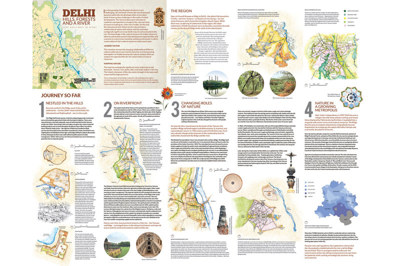
The map tracks Delhi's history of development across twelve centuries to bring together one complete picture of how the city came to be. It presents both the 'then' and the 'now' scenario of its natural resources and observes the city through a very objective and 'real' lens.
It is both an invaluable resource in understanding Delhi and its natural systems as well as an indispensable means to allow citizens to foster a stronger connect with the city they live in but probably do not know much about- yet.
|
|
Delhi: Hills, Forests and a River
Author: Nikhil Dhar
Published by Landscape Foundation India, 2017
Languages :English & Hindi
Open Size 29" x 23" | Folded Size 5.8" x 7.67"
|
|
|
"Nature plays a crucial role in the founding and evolution of towns and cities...its components and related processes give diverse sets of characters to the landscape, in an urban realm. It guides the site planning of the settlements-along rivers, in valleys, on foothills and the spatial organization of built and open areas. With the idea of studying the role of nature in its various forms in the city of Delhi, the Nature
Map of Delhi has been conceptualized. The work tries to understand the role of nature in the history and evolution of the city of Delhi. Along with profiling history, the Map also identifies important natural and designed green areas-urban forest, flood plains, heritage precincts, public parks, biodiversity parks, zoological parks, agricultural land among others.
This perspective of looking at a city opens up many hidden markers that will point towards directions for further research to address various urban environmental issues of vanishing floodplains, polluted rivers, depleting ground water tables and air pollution. It is the start of a special knowledge which, in an advanced stage of evolution, will help in generating sensitive guidelines to make the cities, towns and villages more
livable. Conceptualization in a regional language along with English is an attempt to further reach out to more minds and sensibilities. With the same idea, maps for the cities of Pune and Bangalore are also being prepared in these cities by groups of local professionals."
- DOCUMENTATION CONCEPT NOTE
Delhi: Hills, Forests and a River Map is gorgeous. It invites you to first admire its looks, which it manages without even trying to disguise the fact that it is also clearly bursting with information. You can't wait to delve into it.
The first part of the map looks at twelve centuries of development as linked with the city's water systems and natural resources. It looks at the water systems from the LalKot era (with the Anangtal and Surajkund water-bodies), to Tughluqabad, HauzKhas and the British interventions,up to the pollution-ridden and water-stressed expanding new NCR. Various interesting facts emerge: a mention of the history of the 250-km-long Western Yamuna Canal system that irrigates many districts in Haryana, the fact that Shajahanabad was the first city that acknowledged the importance of the Yamuna, the planting of Prosopisjulifloraon the Ridge and its fencing off from local inhabitants. The sad story of the decline of Delhi's traditional water harvesting systems such as wells, baolisand tanks is traced briefly, followed by a short description of the modernization of the water supply and sewage systems under a freshly constituted municipality.
Sketch maps of the city show different phases of its development, linked with the water systems that fed them. The architectural and landscape backgrounds of the authors show in the inclusion of North signs and graphic scales even in the smallest of sketch maps, a facet that will be appreciated by students and professionals who use the map.
|
|


|
|

| |
|
|
|